What is the true value of your property?
We are pulling back the curtain to show you what developers and builders know. Get the Land Report Analysis and do not leave money on the table!

The Land Report Analysis, a service offering of Devlan LLC, provides you with the knowledge you need about the highest and best use of your property. Not the current value but the potential future value based on development. Know what the big developers know. Be informed. Don’t leave money on the table. We have over 30 years of land development and engineering experience. Get your comprehensive land report analysis today!
About Us
We have over 30 years of land development and engineering experience. We realized that many people do not know the true value of their properties, and when they go to buy or sell, often times they leave money on the table or lose money. We’re here to help. Contact us for more information on how to receive your initial land report.
Experts You Can Trust. Excellent Service.
Make an informed decision when it come to your land. We’re here to help you better understand your options.
Our Services
Drone Services
Green Homes Consulting
Land Acquisition Consulting
Assemblages


Drone Services include:
LiDAR is used for:


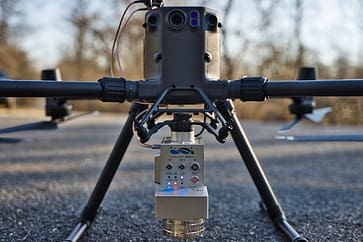
LiDAR (light detection and ranging) is a remote sensing method that can detect objects in real space with relatively high precision and accuracy, depending on the LiDAR unit’s specifications. UAV LiDAR involves a drone flying over a set area while a sensor sends out laser pulses at a rate of 100k-3million pulses per second onto a surface and measuring the time it takes for the signal to return. LiDAR Data is electronically compiled with GPS data and data from the inertial measurement unit (IMU) to create a digital representation of the scanned area in a point file format, which professional surveyors can then use to build a great number of deliverables for their clients.
Drone Equipment:
Drone Software:
LiDAR Equipment:
LiDAR Software:
Devlan's Pilots are FAA Certified and Insured
Contact us for a quote:
devlansolutions@gmail.com


